
The English Way (Camino Ingles) is one of the shorter routes of the Camino de Santiago network on mainland Europe. This route is growing in popularity, every year more and more pilgrims choose this Camino, but it’s still far from being as busy and crowded as the Camino Frances.
For us, the English Way was our 6th Camino de Santiago that we completed in a year and probably the easiest one due to its short distance and easy terrain.
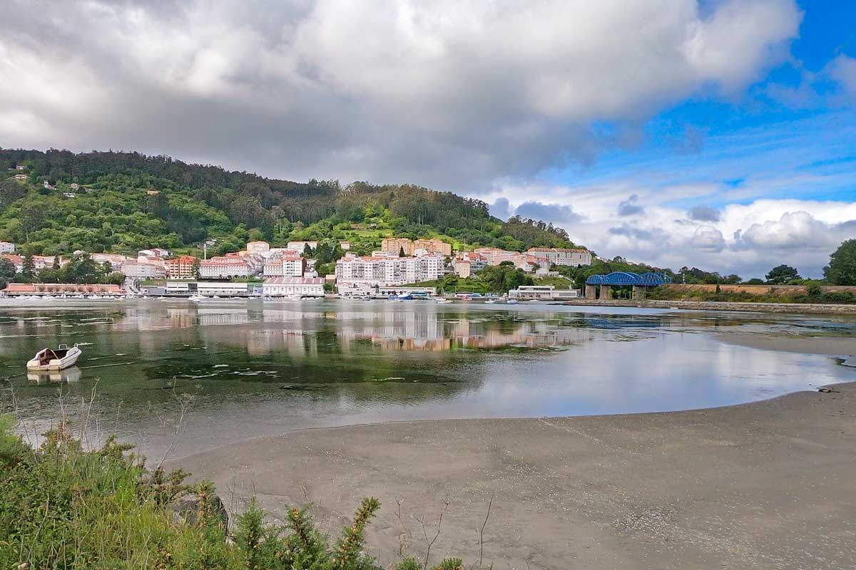
 A beach in Pontedeume, one of the nicest towns on the English Way of St.James
You can find a lot of information for planning your walk in our Camino Ingles detailed guide.
English Way PDFs
We created free downloadable PDF files that contain walking stages and places to stay along the route. These files will help you to plan your pilgrimage on the English Camino.
The video of our walk on the English Camino
GPX files of the English Route
You can download our GPX file for navigating on the English Camino.
The route overview
- Distance – 116 km/72 mi
- Time – 4-6 days
- Starting point – Ferrol
- Finishing point – Santiago de Compostela
- Total ascent (over 5 days) – 2520 m
- Total descent (over 5 days) – 2230 m
- Walking surface – 82 km/51 mi on tar/asphalt; 34 km/21 mi on gravel road/footpath
- Route marking distance poles, yellow arrows, and shells
- Average cost – 35€ per person per day
- Accommodation – public and private albergues, hotels, guesthouses
Travel insurance for the Camino
Walking like any other outdoor activity involves a risk of getting an injury or losing some of your gear. The English Camino is not a very demanding hike through remote areas but walking daily with a backpack is still challenging. Small injuries such as blisters, knee problems, or shin splints are common on the Camino.
Read more about travel insurance for the Camino or get a personalized insurance quote right here!
World Nomads offers simple and flexible travel insurance. Buy at home or while traveling and claim online from anywhere in the world.

 A traditional milestone in the forest marking the English Camino and indicating the distance left to Santiago de Compostela
The English Way – walking stages
The English route starts in the town of Ferrol on the coast of Northern Spain. Like any other Camino route on the mainland it finishes at the Cathedral in Santiago de Compostela.
Places to stay in Ferrol
There is a public albergue in Ferrol. It’s a new albergue situated near the port, 600 m from the starting point of the English Way. Its capacity is 60 people. I’m quite sure you’ll always be able to get a bed there.
If you prefer staying in private room you can stay at one of the hotels.
Stage 1. Ferrol – Neda, 14 km/8,6 mi
- Distance – 14 km/8,6 mi
- Time – 3 hours (moving time)
- Ascent – 178 m
- Descent – 160 m
- Walking surface – 10 km/6,2 mi on tar/asphalt; 4 km/2,4 mi on gravel road and boardwalks
- Walking on the road – 0 km
- Difficulty level – 1 out of 5, very short and easy day

 Elevation profile of the first day on the English Way from Ferrol to Neda. As you can see there are no significant ascents and descents on the route.
 The starting point of the English Camino in Ferrol on Google maps
The English Camino starts at the port of Ferrol, there is a route marking pole next to Sarga Tapas and Raciones restaurant (you can search in Google maps “Inicio del Camino Inglés a Santiago de Compostela” the spot is marked). We didn’t use any GPS or map to find the starting point; we just asked locals where the port (Puerto) was and found the sign quite easily once we got there. From there on the route was marked well.
We started walking late and for this reason, we decided to stop in Neda. If you start early you can continue walking past Neda. The next public albergue is 15 km/9,3 mi from Neda if you want to stay in a public albergue your first walking day will be 29 km/18 mi.

 A map of the stage 1 of the English Camino, the walk from Ferrol to Neda
Highlights
- The port and the historical center of Ferrol
Challenges
- Nothing specific just a lot of walking on a hard surface
Neda
Neda is a nice small town on the river.
Places to stay in Neda
Day 2. Neda – Miño, 26 km/16 mi
- Distance – 26 km/16 mi
- Time – 6-7 hours
- Ascent – 648 m
- Descent – 641 m
- Walking surface – 19 km/11,8 mi on asphalt/tar; 7 km/4,3 mi on gravel/footpath
- Walking on the road – 700 m
- Difficulty level – 4 out of 5, a relatively long walking day with a couple of very steep ascents and descents

 Elevation profile Day 2; Neda to Miño with many ascents and descents
It was a long and challenging day with many places to stop along the route for coffee, lunch, and rest. We stopped 3 times, it made the walk easier. The first half of the route is through suburban areas with not much to see. After that, the route becomes more scenic. We got to walk through the beautiful forest from time to time.
Pontedeume is about halfway through the day, and a great place to stop for coffee or lunch. If you have time you can walk around a bit and do some sightseeing. Another option is to stop here and continue walking the next day.
Note! In Pontedeume the route is marked with metal shells on the ground, don’t miss them.

 Route map of the stage 2 of the English Way, a walk from Neda to Miño
Walking through the forest we saw several stands with shells (a traditional symbol of the Camino) that you could purchase for donation and two or three spots with cooler boxes with cool drinks, juices, and water – for donation as well. We have seen it before on some other Camino routes.
After Pontedeume the scenery becomes less urbanized, with forest and fields scenery.
Highlights
- The historical center of Pontedeume; Torreón de los Andrade, Puente de Piedra, Iglesia Parroquial de Santiago and a couple of other churches.
- Beautiful lush green forest
- Playa Grande de Miño, close to the albergue
Challenges
- A couple of steep ascents in the second half of the day starting from Pontedeume.
- A lot of walking on tar/asphalt which makes your feet quite tired compared to walking on a footpath or gravel.
Miño
Don’t miss the albergue sign in Miño, it’s on the opposite side of the Tourism information sign, pointing in the same direction as the information office. There are signs on the righthand side of the road pointing to the albergue.
Places to stay in Miño
Day 3. Miño – Presedo, 23 km/14,2 mi
- Distance – 23 km/14,2 mi
- Time – 5-6 hours
- Ascent – 700 m
- Descent – 556 m
- Walking surface – 21 km/13 mi on tar/asphalt; 2 km/1,2 mi on footpath/gravel
- Walking on the road – 4 km/2,4 mi, the last 3 km/1,8 mi to Presedo are on the road
- Difficulty level – 4 out of 5

 Elevation profile Day 3 of the English Way, the walk from Miño to Presedo
The first half of the walk to Betanzos went quickly, we stopped in the town for about 1-1,5 hours to drink coffee and to do some sightseeing, there are many interesting places to see luckily most of them are on the route or not far away from it.
After Betanzos the Camino continued climbing up and down almost non-stop. The last 3 km/1,8 mi we had to walk on the road. It wasn’t a busy road but some trucks and buses were driving by.
During the whole day, we saw only four pilgrims but when we arrived in Presedo there were 6 other people in the albergue.

 Route map of stage 3 of the English Way, the walk from Miño to Presedo
Highlights
- The beautiful forest outside Miño
- The historical center of Betanzos; the Plaza of Irmáns García Naveira, Plaza de la Constitución, several churches, and historical buildings.
Challenges
- Walking on tar road/asphalt all day
- Many steep ascents and descents
- Walking on the road for the last 3 km/1,8 mi

 Entering Betanzos, a beautiful town on the English Way
Presedo
Presedo is not a town there is only an albergue and a restaurant. Your food options are to eat in the restaurant (about 500 m away from the albergue) or to bring food from Betanzos and cook (the albergue has a kitchen). There are two or three big supermarkets in Betanzos (Lidl, Eroski, Gadis, etc.), about 100 m away from the Camino. At the exit of the city; at the roundabout turn right and go two or three blocks down the street.
Places to stay in Presedo
- High-end | Rectoral de Cines (away from the Camino but according to the pilgrim’s reviews they offer free pick up and drop off) |
Day 4. Presedo – Sigüeiro, 37 km/23 mi
- Distance – 37 km/23 mi
- Time – 8-9 hours
- Ascent – 673 m
- Descent – 581 m
- Walking surface – 22 km/13,6 mi on tar/asphalt; 15 km/9,4 mi on gravel/footpath
- Walking on the road – 4 km/2,4 mi
- Difficulty level – 5 out of 5
 Elevation profile Day 4; Presedo to Sigüeiro
Note! We wanted to have one long walking day on the English Way, and for this reason, we decided to walk two stages in one day. You can split this day into two stages; Presedo – Hospital de Bruma, 13 km/8 mi and Hospital de Bruma – Sigüeiro, 24 km/15 mi. A good thing about walking a short stage to Hospital de Bruma is that you’ll arrive there before the majority of pilgrims (who come from Betanzos) which can guarantee you a spot.

 A map of the stage 4 of the English Camino from Presedo to Sigueiro
The first 30 km/18,6 mi went quickly. The main ascent for the day was right at the beginning in the first 2 hours or so. We stopped for coffee several times, it was a nice day. A part of the walk was through the beautiful forest. The last 6-7 km/3,7-4,3 mi were not that pleasant. First of all because we started getting tired and second, because the route got very monotonous (walking next to a busy road). We were very happy when we finally reached Sigüeiro.
Highlights
- Beautiful Galician forest
- At 16 km/10 mi in front of the bar, there are several metal and stone sculptures of people and animals, the most impressive is a giant dinosaur.
Challenges
- Walking on tar/asphalt for a big part of the day
- A very long distance
- Several steep ascents in the first half of the day
- The last 4-5 km/2,4-3,1 mi to Sigüeiro next to the highway and then 1 km/0,6 mi on the road (not very busy) and past an industrial area.
Sigüeiro
This town is a great stop before Santiago. There are a couple of private albergues and several hotels but no public albergue here.
Places to stay in Sigüeiro
Day 5. Sigüeiro – Santiago de Compostela, 16,5 km/10,2 mi
- Distance – 16,5 mi/10,2 mi
- Time – 4-5 hours
- Ascent – 321 m
- Descent – 292 m
- Walking surface – 10 km/6,2 mi on tar/asphalt; 6,5 km/4 mi on footpath/gravel
- Walking on the road – 0 km, no road walking today!
- Difficulty level – 2 out of 5
 The elevation profile of Day 5, the walk from Sigüeiro to Santiago de Compostela
If you want to arrive in time for the pilgrims’ mass in the Cathedral (which starts at 12 pm) it’s better to leave early, at least at 8 am to have enough time. Note! You’re not allowed to enter the cathedral with a big backpack you can leave it in your hotel in Santiago or you store it at the storage and pick it up later. The storage is 200 m from the Cathedral in front of the Pilgrim’s Reception Office. They charge 4 euros for 24 hours.

 Route map of the last stage of the Camino Ingles from Sigueiro to Santiago de Compostela
On out last day time went very fast. We didn’t even notice how we got to the outskirts of Santiago, from there it’s about 5 km/3,1 mi more to walk through the city to the cathedral. There is a church Parroquia de San Caetano on the way where you can get the last stamp before the cathedral. Out of all the Camino routes we’ve done the city part of the English route is one of the best and the shortest.

 The enchanted forest on the last day of the English Camino just before Santiago de Compostela
Highlights
- The beautiful forest Bosque Encantado (Enchanted forest) in the middle of the day
- Arriving in Santiago de Compostela – the highlight of the route. It’s a magical moment to see hundreds of pilgrims coming from different directions to Plaza de Obradoiro.
Challenges
- Several short ascents and descents
- On the last 5 km/3,1 mi a part of the route goes through the industrial outskirts of Santiago de Compostela.
Santiago de Compostela, the end of the English route
Santiago de Compostela is a great place to spend a couple of day after finishing the Camino. There are many interesting things to do here. One of our favorite is to go out and try local tapas, they are delicious. The best street to go out for tapas is Rua do Franco. You can join a tapas tour of Santiago.
Things to do in Santiago de Compostela
If after finishing the English Way you feel like walking for a couple of more days the Camino Finisterre is a great option. It starts from the cathedral in Santiago de Compostela and takes you to the Finisterre (the end of the world). If you don’t feel like walking anymore you can do a day tour to Finisterre.
Places to stay in Santiago
I’d like to mention one special place that has been accommodating pilgrims for centuries – Hospedaria San Martín Pinario or Seminario Mayor. It’s one of our favorite places to stay in Santiago de Compostela. They have special rooms for pilgrims. Rooms can be booked over the e-mail at [email protected] or the phone (+34) 981 56 02 82.
I strongly recommend booking it in advance, especially in the peak season. We were there in June and it was booked two weeks ahead. They have renovated rooms (more expensive but more comfortable) that can be booked online.
More places to stay in Santiago
How to get the Compostela certificate in Santiago?
The Pilgrim’s Reception Office is open from 10 am to 6 pm if there are many people inside they might close the gate earlier.
In the peak season when there are many pilgrims there is a number system that determines your position in the queue. It’s a very easy and convenient system you don’t have to sit there for hours waiting for your turn. You can go back to your hotel, or walk around the city keeping an eye on the queue online.
To get your Compostela certificate you need a Credential (pilgrim’s passport) with stamps and a passport or an ID document. The Compostela is free. You can get the Certificate of Distance. It is similar to the Compostela but has more details, it costs 3€.
You need two stamps per day if you walk 100 km on any Camino route which means two stamps for every day of the English Way.
English Camino planning resources
Questions or Comments?
Got any questions or comments? We would love to help! All questions and comments will be answered by us personally in Buy Me a Coffee. Click below and ask away.
Feel free to support our site by buying us a coffee!
Like this post? Pin it!


The pretty half of Stingy Nomads, responsible for all our land adventures (hiking, climbing, walking the Camino) and following them write-ups. Alya loves walking since she was a child, she prefers to walk 1000 km with a backpack rather than to do a 10 000 km road trip (actually any road trip). Alya is a big fan of Latin America, the Spanish language, and dancing. Every time we go away she desperately misses our dog Chile.
Please visit our sponsor:
Our Sponsor